Header Ticker
TSXKRR


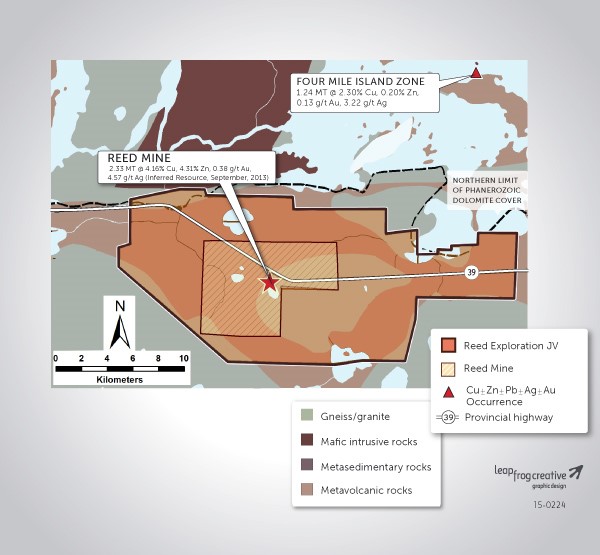
RNC holds a 30% interest in the Hudbay Reed Exploration Joint Venture as a result of RNC’s acquisition of VMS Ventures in 2016.
Hudbay is 70% owner and acts as the operator of the joint venture with authority and discretion of the exploration and potential development of the property and has exclusive rights to purchase and market the ore produced from the property.
The joint venture relates to four separate but contiguous claims blocks surrounding the Reed Copper Deposit JV: the Tower Zone, Super Zone Claim, Northwest Zone Claim and Northeast Zone Claim properties.
Exploration to date has included airborne and ground geophysical techniques including VTEM and ground TDEM surveys. Targets have been discovered and drill tested (Reed North discovery) with interesting intersections however no significant economic zones of mineralization have been located.
Geology and Mineralization
The general area of the Reed Mine is characterized by a thin layer of younger Paleozoic dolomite and sandstone which effectively blankets the highly prospective Flin Flon-Snow Lake greenstone belt. These younger rocks are part of the Western Canada Sedimentary Basin.
The geological architecture of the four properties that comprise the Reed Mine Joint Venture agreement with Hudbay Minerals is very similar. The presence of bimodal volcanism overprinted with near solid sulphide to disseminated sulphide mineralization accompanied by a suite of alteration minerals usually present in and around base metal massive sulphide type deposits has been documented on the properties during diamond drill testing of integrated geophysical and geochemical survey data. Mineralization has been detected at or near the contact with mafic and felsic volcanic rocks which is similar to the setting of the Reed Copper Deposit. Mineralization has been primarily pyrrhotite with lesser chalcopyrite, sphalerite and magnetite.
The Reed Mine and the past producing Dickstone and Spruce Point copper-zinc deposits are hosted in the Four mile Island Assemblage of mafic and felsic volcanic rocks and associated intrusions.
Results
Airborne geophysical surveys (VTEM) have been flown over the various exploration properties since 2006 and these surveys have been flown in two directions in some cases. Numerous conductive zones with associated or coincident magnetic responses have been outlined, providing both VMS Ventures and later Hudbay Minerals with drill targets. Down-hole EM surveys have been used to detect off-hole anomalies that also become drill targets.
The prioritizing of these anomalies for drill testing has been further defined by the use of Mobile Metal Ions soil geochemistry which helps to determine those bedrock-hosted geophysical anomalies with elevated metal contents. To date no economic mineralization has been detected on any of the exploration properties however some exceptional intervals of base and precious metals have been intersected in association with bimodal volcanic rocks. These are summarized below in Table 1.
Table 1: Summary of historic assay results, Reed Exploration JV
|
DDH |
INTERVAL (m) |
Cu% |
Zn% |
Au g/t |
Ag g/t |
|
RLE021 |
3.95 |
9.31 |
1.87 |
3.59 |
35.53 |
|
RLE022 |
4.15 |
2.16 |
0.18 |
0.71 |
8.01 |
|
RLE004 |
0.34 |
5.41 |
0.27 |
1.58 |
7.57 |
|
RLE006 |
7.18 |
7.44 |
0.23 |
0.48 |
7.57 |
|
44.9 |
0.79 |
0.39 |
0.16 |
1.58 |
|
|
RLE007 |
2.23 |
5.94 |
0.27 |
0.4 |
5.5 |
|
24.7 |
0.21 |
1.18 |
0.08 |
0.79 |
The nature of these drill intercepts in terms of metal contents, alteration mineral assemblages and EM conductive anomalies indicates the area of exploration interest is extensive and highly prospective for base metal massive sulphide type mineralization. Of particular importance is the presence of these characteristics in association with a sequence of bimodal volcanic rocks in which the larger VMS-type deposits occur, worldwide.
In November 2015, VMS completed a seven drill hole exploration program totaling 4,870 m (Table 2). Areas targeted were approximately 300 m to 2.3 km from the operating Reed Mine. Drilling was conducted on the Reed Mine lease as well as the Exploration JV property. Borehole electromagnetic surveys were conducted on all the drill holes and Reed Mine and Highway Zone stratigraphy was recognized in most of the core holes. Three drill holes, RLE036, RLE040 and RLE042 require follow up work based on favourable geology and the borehole results. Assay data to date are shown in Table 3.
Table 2: Drill Collar Information for the 2015 Drilling Program
|
Hole Number |
UTM East |
UTM North |
Elevation(m) |
Length |
Azimuth |
Dip |
|
RLE036 |
393401.8 |
6050036.4 |
284 |
1056 |
359.9 |
-65 |
|
RLE037 |
394440.2 |
6049360.8 |
299 |
1094 |
209.3 |
-65 |
|
RLE038 |
395277.8 |
6049488.4 |
295 |
279 |
150.1 |
-55 |
|
RLE039 |
396073.7 |
6049703.6 |
288 |
737 |
110.0 |
-55 |
|
RLE040 |
395971.7 |
6049182.4 |
295 |
713 |
109.7 |
-60 |
|
RLE041 |
395192.6 |
6048894.0 |
308 |
311 |
180.6 |
-60 |
|
RLE042 |
394876.1 |
6048501.6 |
290 |
680 |
209.4 |
-60 |
Notes:
Collar Coordinates – NAD83 Zone 14U
Holes spotted with Reflex APS Instrument
Table 3: Assay Results to Date for the 2015 Drilling Program
|
Hole Number |
|
From (m) |
To (m) |
Core Length (m) |
Cu% |
Zn % |
Ag g/t |
|
RLE036 |
|
447.40 |
456.40 |
9.0 |
0.07 |
0.98 |
0.86 |
|
RLE037 |
Including: |
452.40 |
453.40 |
1.0 |
0.09 |
1.52 |
1.30 |
|
RLE038 |
Assays Pending |
||||||
|
RLE039 |
Assays Pending |
||||||
|
RLE040 |
Assays Pending |
||||||
|
RLE041 |
Assays Pending |
||||||
|
RLE042 |
Assays Pending |
||||||
Notes: Intervals represent core lengths, true widths are unknown
Straight from our desk, to your inbox.
Subscribe To Our News Releases


© All rights reserved Karora Resources 2024